|
Antarktis BAT |
|
Antarktis Weitere Informationen |
|
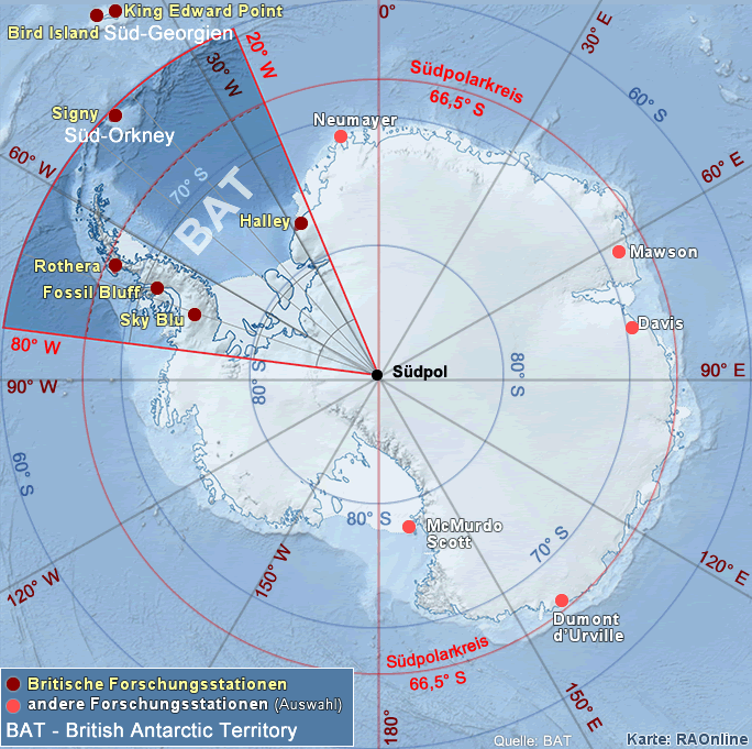
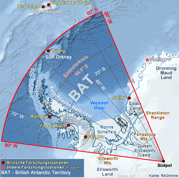
| British Antarctic Territory |
 |
| Britische Überseegebiete in der Antarktis |
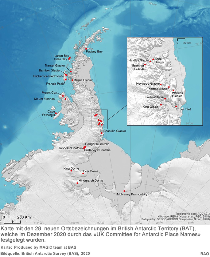
| 2020: Neue Ortsbezeichnungen im BAT |
|
Die Regierung der British Antarctic Territory (BAT) gab am 3. Dezember 2020 28 neue Ortbezeichungen im BAT-Gebiet. Mit den neuen Ortsnahmen zum Ende des Jubiläumsjahres «200 Jahre seit der Entdeckung der Antarktis» ehrt die Regierung Persönlichkeiten, welche in den letzten 50 Jahren einen ausserordentlichen Beitrag zum Verständnis, zum Schutz und zur Entwicklung der Antarktis beigetragen haben.
1819 wurden die Süd-Shetland-Inseln entdeckt. 1820 setzten Menschen erstmals ihre Füsse auf den Antarktischen Kontinent.
Das Das «UK Committee for Antarctic Place-Names» hat die eingereichten Namensvorschläge geprüft und genehmigt.
Die Namensgebung folgte international gültigen Prinzipien und Vorgehensweisen. Die Ortsnamen müssen einen Bezug zu Personen haben, welche nachweislich sich Verdienste im Zusammenhang mit der wissenschaftlichen Forschung, der Erkundung und der Versorgung der Antarktis erworben haben. 2020 wurden für die geografischen Ortsbezeichnungen Namen von Wissenschaftler, Forschern, Logistikern und anderen Fachgebieten, welche einen bedeutenden Beitrag zur wissenschaftlichen Erforschung der Antarktis für das Vereinigte Königreich geleistet haben.
Eine geografische Ortsbezeichnung in der Antarktis besteht in der Regel aus zwei Teilen: Dem Namen der geehrten Person wird ein geografischen Oberbegriff nachgestellt. Der Oberbegriff bezieht sich auf die Eigenschaft des ausgewählten Objekts wie Gletscher (Glacier), Berg (Mount), aus dem Eis ragende Bergspitzen (Nunataks), Bergspitze (Peak), Bucht (Bay) usw.
|
 |
|
| Bamber Glacier |
Glacier on Adelaide Island, about 9 km long and 2 km wide, flowing west from between Mount Reeves and the un-named mountains to the north. Named for Professor Jonathan Bamber (b. 1962), Professor of Physical Geography, University of Bristol. Specialist in using satellite altimetry to study the morphology and dynamics of the Antarctic and Greenland ice sheets, and the contribution of land ice to sea-level change. Glacier flowing north from Wilson Mountains into Hilton Inlet, Palmer Land. About 17 km long and about 2.5 km wide at the entrance to Hilton Inlet. |
| Bone Glacier |
Named for Mr Douglas Bone (b. 1945). He wintered at Signy 1967 and 1968 as an Assistant Biologist, and then joined the British Antarctic Survey's Marine Life Science Division. He was a leading figure in the scienti!c commissioning of the RRS James Clark Ross and worked every season in Antarctica to 2005. |
| Bremner Glacier |
Glacier flowing north from the Peck Range to meet Beaumont Glacier, east of Mount Wever, Palmer Land, about 20 km long and about 3.5 km wide. Named for Mr Steven Bremner (b.1959), who spent 35 years as an engineer at BAS and played a key role in the development of technology for BAS science, including responsibility for scientific marine engineering for the RRS Sir David Attenborough. Dome rising to about 550 m at the eastern end of Fowler Peninsula, Zumberge Coast. |
| Corr Dome |
Named for Hugh Corr, glaciologist and radar engineer at British Antarctic Survey from 1986 to 2017. He developed and applied a range of geophysical measurement techniques, particularly ice-penetrating radar systems, from aircraft to study the ice sheet and the continental structure beneath. |
| Cox, Mount |
Peak in the Rouen Mountains about 2950 m high between Mt Hankey and Mt Hall with 1500 m cliffs and an un-named ridge on the east side above Peel Cirque.
Named for Mr Nicholas Cox MBE (b. 1953) who worked for BAS for over 40 years in a variety of roles, including three Antarctic winters. Manager of the UK's Arctic Research station at Ny-Ålesund, Svalbard which he helped establish in 1991.
A group of nunataks extending about 12 km N-S and 5 km W-E, including Mount Edward and forming part of the Sweeney Mountains, Southern Palmer Land. |
| Dudeney Nunataks |
Named for physicist Dr John Dudeney OBE (b. 1945) who joined British Antarctic Survey in 1966. Research scientist in the field of ionosphere/magnetosphere physics, including two Antarctic winters and roles as Base Commander, Research Leader, Head of BAS science division and Deputy Director. Internationalroles as UK representative to the Council of Managers of National Antarctic Programmes and a member of the UK delegation to the Antarctic Treaty. Summit at about 2550 m high on the eastern side of Elgar Uplands, Alexander Island, between Gerontius Glacier and Hampton Glacier. |
| Fiennes, Mount |
Named for Virginia (Ginny), Lady Twistleton-Fiennes (1947-2004). Explorer and polar radio operator, including research on very low frequency radio propagation. She played a leading role in the conception, planning and logistics support for the Transglobe Expedition 1979-82, led by Sir Ranulph Fiennes. First woman invited to join the Antarctic Club 1985, first female recipient of the Polar Medal 1987. |
| Fothergill, Cape |
Prominent cape on the north side of Latady Island, forming the eastern edge of Attenborough Strait. Named for Alastair Fothergill OBE (b.1960). Head of BBC Natural History Unit 1992-1998. Producer of high.impact documentary series advancing public awareness of Antarctica and climate change. Locally prominent peak (1136 m), with imposing cliffs on its eastern side, on the horseshoe shaped ridge east of Mount Liotard, Adelaide Island. |
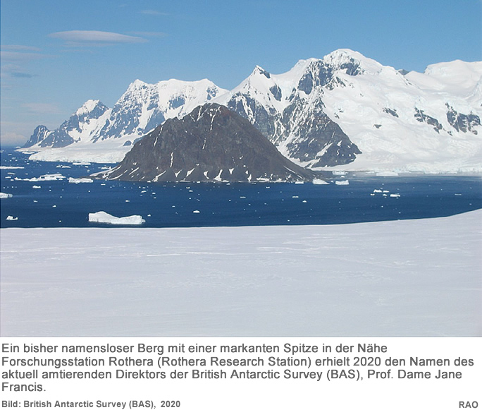
| Francis Peak |
Named for Professor Dame Jane Francis (b.1956), pioneering palaeobotanist and palaeoclimatologist specialising in the study of fossil plants, especially woods, and their use as tools for climate interpretation and information about past biodiversity in the polar regions. Director of the British Antarctic Survey, from 2013, and Chancellor, University of Leeds, from 2018. |
| Fricker Ice Piedmont |
Ice Piedmont about 12 km wide and 6 km deep on the eastern side of Adelaide Island. It is bounded to the west by Mount Reeves and Mount Bouvier, and forms the coastline of Adelaide Island along Barlas Channel.
Named for Professor Helen Amanda Fricker (b.1969), Head of Glaciology at Scripps Institution of Oceanography, San Diego. Glaciologist on NASA's IceSat-2 programme and a significant figure in satellite altimetry of the Antarctic and Greenland Ice Sheets.
Bay about 4 km wide and 3 km deep between Weaver Point and Tula Point at the northern end of Renaud Island, Biscoe Islands. |
| Giles Bay |
Named for Dr Katharine Giles (1978-2013), Lecturer at University College London, whose research focussed on sea ice, ocean circulation and wind patterns, and pioneered the use of satellite altimetry to measure the thickness of Arctic and Antarctic sea ice.
Glacier about 18 km long and 3 km wide flowing north from the Wegener Range, Palmer Land, to the west of Heezen Glacier, to join Maury Glacier. |
| Heywood Glacier |
Named for Professor Karen Heywood (b. 1961), Professor of Physical Oceanography, University of East Anglia. Leader of six oceanographic research cruises to Antarctica since 1995, including Pine Island Bay, the Weddell Sea and the Scotia Sea and a pioneer of the use of autonomous ocean gliders.
Glacier flowing north from Wilson Mountains into Hilton Inlet, Palmer Land, about 20 km long and about 3 km wide at the entrance to Hilton Inlet. |
| Hindley Glacier |
Named for Mr Christopher Hindley (1948 – 2020), BAS Ships Programme and Operations Manager, 2000 to 2020. He played a key role in the development of BAS marine science through programming marine scientific cruises, and was responsible for the shipping of materials for the building of Halley VI Research Station. |
| Hindmarsh Dome |
Named for Professor Richard Hindmarsh, a glaciologist and ice sheet modeller at the British Antarctic Survey for more than 25 years. He developed advanced numerical models of ice sheets, including Antarctica, and worked on modelling subglacial bedforms.
Dome rising to about 1350 m on the west side of Fowler Peninsula, Zumberge Coast, about 50 km to the west of Haag Nunataks. |
| King Dome |
Named for Dr Edward King (b.1954), geophysicist at the British Antarctic Survey from 1986. King used seismic techniques to study the structure of the Antarctic continent and surrounding ocean floor, and was a key part of a team that developed and used ground-penetrating radar techniques to study ice stream dynamics.
Glacier about 25 km long and 2.5 km wide flowing east from Dana Mountains, into New Bedford Inlet between Mount Cummings and Court Nunatak. |
| King Glacier |
Named for Professor John King (b. 1955), meteorologist at British Antarctic Survey from 1984, including roles as Senior Atmospheric Scientist and member of the International Commission on Polar Meteorology.
Glacier about 15 km long and 2.25 km wide flowing south-west into Mosby Glacier, Lassiter Coast, to the east of Fenton Glacier. |
| Ladkin Glacier |
Named for Russell Scott Ladkin (b.1966). Meteorologist at British Antarctic Survey, including wintering at Halley Research Station in 1990 and 1991, and later the engineer responsible for airborne meteorology instrumentation.
Bay about 10 km wide and 3 km deep between Palosuo Islands and the west side of Renaud Island, Biscoe Islands. |
| Laxon Bay |
Named for Professor Seymour Laxon (1963-2013), Director, Centre for Polar Observation and Modelling at University College London. His research pioneered the use of satellite altimetry to measure sea ice thickness and surface circulation in the Arctic Ocean. His work provided evidence that led to the development of the European Space Agency's CryoSat mission.
Glacier about 12 km long and 4 km wide flowing south.west into Square Bay, Fallières Coast. Its terminus merges with Swithinbank Glacier to the south. |
| Morris Glacier |
Named for Professor Elizabeth M. Morris OBE (b. 1946), a glaciologist with the British Antarctic Survey, including as Head of the Ice and Climate Division, and later with the Scott Polar Research Institute. She was in the vanguard of British women scientists in Antarctica. Her work to understand the mass balance of ice sheets encompassed field measurement of snow accumulation rates and temperatures, and a range of measurements to ground-truth satellite observations of the ice sheet. |
| Mulvaney Promontory |
Named for Dr Robert Mulvaney OBE (b. 1958), a glaciochemist with the British Antarctic Survey.
Mulvaney led ice core drilling projects to bedrock on Berkner Island, James Ross Island and Fletcher Promontory and was part of the European Project for Ice Coring in Antarctica (EPICA), as well as numerous other ice coring campaigns. He also worked on a range of ice cores from Greenland and Svalbard. He was closely linked to the technological development of continuous flow analysis of ice cores.
A group of nunataks extending about 9 km N-S and 6 km W-E, including Mount Smart and forming part of the Sweeney Mountains, Southern Palmer Land. |
| Pinnock Nunataks |
Named for engineer and physicist Dr Michael Pinnock (b.1954). He joined British Antarctic Survey in 1976, wintered at Halley Research Station, 1977, 1978 and 1981, and established the long-running SUPERDARN radar array at Halley. Later he held senior roles as Research Leader and Board member for Science Delivery.
Bay about 7.5 km wide and 6 km deep between Cape Fairweather and Shiver Point, Oscar II Coast. |
| Pudsey Bay |
Named for Dr Carol Pudsey (b.1955), who spent over twenty years at BAS as a marine geologist. She specialised in the Quaternary of the Scotia Sea and Weddell Sea and integrated geophysical surveys with sediment coring, taking a particular research interest in the collapsing ice shelves of the north-east Antarctic Peninsula. She was the first woman Principal Scientist on a BAS marine science cruise (1990), and also took part in a number of International Ocean Drilling Program cruises.
A group of nunataks extending about 10 km N-S and 7 km W-E, including Mount Ballard and forming part of the Sweeney Mountains, Southern Palmer Land. |
| Rodger Nunataks |
Named for physicist Professor Alan Rodger DSc (1951-2020). He joined the British Antarctic Survey in 1972 and wintered at Faraday Research Station in 1973 and 1974. He was a key leader in space weather research, not only in the UK but worldwide. Long serving member of the BAS executive team with responsibility for science strategy, and Interim Director, 2013.
Glacier about 12 km long and 3.5 km wide flowing south from Farman Highland into Keller Inlet. |
| Shanklin Glacier |
Named for Jonathan D. Shanklin (b. 1953), Meteorologist at the British Antarctic Survey from 1977, later Head of the BAS Meteorology and Ozone Monitoring Unit. He was a member of the BAS team led by Joseph Farman (Farman Highland) that discovered the Antarctic Ozone Hole in 1985.
Glacier about 23 km long and 3 km wide, flowing north from the Wegener Range, Palmer Land, between Fogg Highland and Heezen Glacier to enter Violante Inlet. |
| Thomas Glacier |
Named for Professor David N. Thomas (b. 1962), sea ice ecologist, with six expeditions to the Southern Ocean. He held senior roles at Bangor University to 2020, and was later Professor of Arctic Ecosystems Research at the University of Helsinki.
Glacier about 14 km long and 3 km wide flowing north.west from Mount Deeley to enter Lallemand Fjord between Orford Cliff and Neb Bluff. |
| Tranter Glacier |
Named for Professor Martyn Tranter (b.1956), Professor of Polar Biogeochemistry, University of Bristol. Specialist in the fields of biogeochemical processes in glacial meltwater and microbial life in sub-glacial environments.
Glacier about 20 km long and 3 km wide, flowing north from the Wegener Range, Palmer Land, into Mason Inlet south of Fogg Highland and west of Clowes Glacier and Kemp Peninsula. |
| Watkins Glacier |
Named for Dr Jonathan L. Watkins (b.1955), marine biologist at the British Antarctic Survey, 1981-2016. Specialist in the role of Antarctic krill in the southern ocean ecosystem, including many research cruises to South Georgia and the Scotia Sea. |
| Turner Inlet |
Named for Dr John Turner (b. 1953), meteorologist at the British Antarctic Survey from 1986. Dr Turner has held senior roles international climate organisations including Chair of the SCAR Antarctic Climate Change and the Environment Advisory Group, and President of the International Association of Meteorology and Atmospheric Sciences (IAMAS). |
|
|
 |
|
Britische Überseeterritorien |
|
 |
nach
oben
| Links |
|
 |
|
Externe Links |
|