| Bhutan's
glaciers and glacial lakes: Lunana |
 |
Bhutan Glaciers - Glacial Lakes |
|
Bhutan Information |
|
|
 |
|
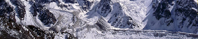
Lunana's
glacial lakes: Luggye, Raphstreng and Thorthormi Tsho |
The partial
breaching of Lake Luggye Tsho in 1994 caused a catastrophic GLOF, the
memory of which is still fresh in the minds of people who witnessed it.
This GLOF will in all likelihood go down in the history of floods in Bhutan
as the most catastrophic event ever recorded both in terms of its magnitude
and in terms of the damage it wreaked on the lives, property, and infrastructure
of the people downstream.
The severity of this event prompted the Department
of Geology and Mines (under the Ministry of Trade and Industry, Royal Government
of Bhutan), to initiate a number of research activities on the glaciers
and glacial lakes in the country.
Numerous
studies were conducted on glacial lakes in Bhutan as part of joint Japan-Bhutan,
India-Bhutan, and Austria-Bhutan projects from 1995-2004. These studies
led to many scientific articles highlighting the risks associated with
the lakes, discussing the mechanisms of lake expansion, and assessing the
stability of the lakes. Previous sections cited some of these.
This
section presents different scenarios regarding lake expansion and draws
both from earlier work by different experts and from the results of the
present work. The discussions focus mainly on the lakes in the Pho Chu
basin.
The
first detailed work on the expansion of glacial lakes in the Bhutan Himalaya
was a time series of sketches of the major glacial lakes in the Lunana region
by Ageta et al. (2000). His subsequent study discussed the evolution of
these lakes in detail using maps, photographs, and satellite images.
Ageta
also studied and discussed the risk that possible outbursts pose on the
geophysical environment in and around the lakes.
 |
|
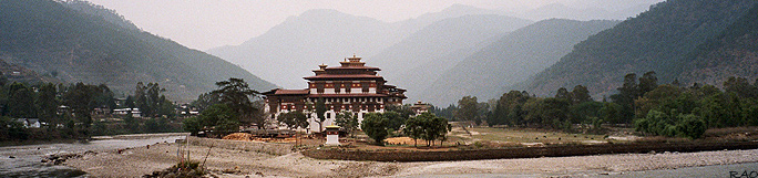
Punakha
Dzong: Confluence of Mo Chhu and Pho Chhu |
top
|
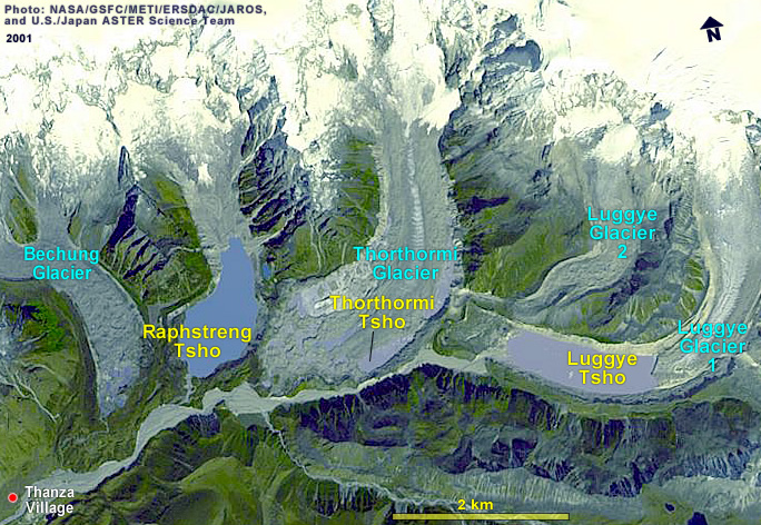
Luggye
Tsho |
 |
Lake
Luggye Tshois an end moraine-dammed lake in the Pho Chu basin of the Lunana
region. As late as the 1950s, there were no indications of any lakes being
associated with Luggye glacier. The first lake appeared only in 1967 (Gansser
1970) as a supraglacial lake and was measured to be 0.02 sq.km in 1968.
The
depth of Luggye Lake (picture) was measured in 2000 and shown to be 142m. This glacial
lake suffered an outburst event on 7th October 1994. The GLOF from Lake
Luggye Tsho caused much damage to the downstream valley, including the
religiously important Punakha Dzong. After the breach, the lake continued
to grow towards the glacier snout and the glacier continued to retreat;
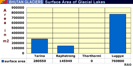
in 2001 the lake area measured 1.12 sq.km. The exposure of ice cliffs on
the glacier snout show calving, which contributes to the expansion of the
lake towards the glacier.
The
outlet channel is at the same level as the lake surface and has a gentle
slope. Evidenced by its bumpy topography, this terminal moraine has an
ice core. Both the continuous sliding of the left lateral moraine at the
outlet and the presence of an ice core contribute to the possibility of
blocking of the previously breached outlet so that the lake could at some
time in the future suffer another GLOF event).
 |
| If
the outlet of Lake Luggye Tso (picture) is blocked by landslides from the left lateral
moraine it will cause the water level of the lake to rise, risking a GLOFevent with serious consequences for the Thorthormi lakes further downstream,
especially since the Thorthormi glacier has already weakened the left lateral
moraine (Ageta et al 2000). |
|
Austrian experts Leber and Hausler (2002) concur
about the risk from Lake Luggye Tso.
In
fact, of the possible scenarios that this group examined during their risk
assessment of the Luggye GLOF, the blockage of the outlet by a landslide
from the left lateral moraine was considered the "major risk" (Leber and
Hausler 2002). This group recommended that the active sliding zone on the
left lateral moraine be stabilised at the outlet to allow free flow of
water from the lake. In contrast, Dorji (1996) observed no immediate GLOF
risk from this lake because of its wide outlet channel. He commented that
the risk of flood from this lake is not imminent as the outlet channel
is wide enough to discharge any amount of water that will accumulate.
top
|
Raphstreng
Tsho |
|
 |
| Lake
Raphstreng Tsho(picture) lies at an altitude of 4360m. This lake appeared as a supraglacial
lake in a 1958 topographic map; topographic maps from 1960 showed that
the lake's area was 0.15 sq.km. In 1986 it was 1.65 km long, 0.96 km wide,
and 80m deep (Sharma et. al. 1986). |
|
Nine years later, the Indo-Bhutan Expedition
of 1995 measured a maximum length of 1.94 km, width of 1.13 km, and depth
of 107m (Ageta et al 2000). The depth measured in 1999 was about 100m.
Some
researchers believe that the lake's present dimensions represent its maximum
since the upstream section has already reached the bedrock wall. However,
field photographs show that the glacier snout is undergoing extensive calving
and that the lake can still expand a few hundred more metres.
 |
Prior
to the 1994 flood from Lake Luggye Tsho, the left lateral moraine was 295
to 410m wide (Bhargava 1995). Toe erosion of the moraine initiated by the
flood has reduced the width to 178m. This weakening of the lake barrier
and the large size of the lake caused grave concern to the Government of
Bhutan. An immediate investigation of the stability of the lake was undertaken
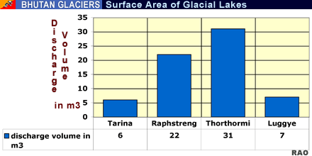
in 1995. Three phases of mitigation work were carried out on this lake
from 1996 to 1998 in an attempt to lower the water level by about 4m. A
channel of 78.5m in length and 36m wide at the outlet was manually widened
and deepened at the lake outlet. Nevertheless, the risk of a GLOF cannot
be ruled out because a large volume of water is still stored in the lake
and a chain effect of GLOFs from other adjacent lakes could occur. An additional
threat to the stability of Lake Raphstreng Tsho (picture) comes from hydrostatic
pressure exerted by the Thorthormi lakes, from which Lake Raphstreng Tsho is separated by only a moraine wall.
Source:
ICIMOD, International Centre for Integrated Mountain
Development 2008
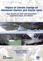
Extract
of Impact of Climate Change on Himalayan Glaciers and Glacial Lakes: Case
Studies on GLOF and Associated
Author(s):
Bajracharya, S. R.; Mool, P.; Shrestha, B. 2007 |
|
top
|
| Publications |
 |
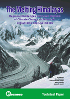
| Regional
Challenges and Local Impacts of Climate Change on Mountain Ecosystems |
 |
| 1.1
MB PDF-File |
 |
| 244
KB PDF-File |
|
|
 |
 |
| 3.9
MB PDF-File |
|
Case Studies
on GLOF and Associated Hazards in Nepal and Bhutan (2007)
This
study, prepared in close cooperation with and supported by the United Nations
Environment Programme Regional Office for Asia and the Pacific, investigates
the impact of climate change on glaciers and glacial lakes in two major
glacial hotspots in the Himalayas: the Dudh Koshi sub-basin in the Khumbu-Everest
region in Nepal, and the Pho Chu sub-basin in Bhutan. |
|
 |
|
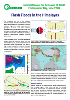
| Source: United Nations Disaster Management Team, 2005 |
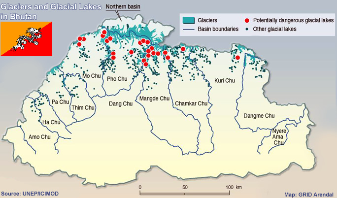
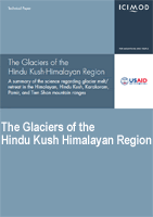
| ICIMOD: The Glaciers of the Hindu Kush-Himalayan Region |
 |
| 1.1
MB PDF-File |
|
| A summary of the science regarding glacier melt/retreat in the Himalayan, Hindu Kush, Karakoram, Pamir, and Tien Shan mountain ranges |
|
 |
 |
| 6.5
MB PDF-File |
|
| Food security in the Hindu Kush Himalayas and the additional burden of climate change |
|
 |
| Climate Change |
Glacial Lakes |
|
 |
top
| Information on Bhutan |
|
| Links |
|
 |
|
External
link |
 |
 |
 |
 |
 |
| GRID-Arendal
News |
NASA's
Global Change Master Directory |
United
Nations Environment Programme |
World
Glacier Monitoring Service |
International
Centre for Integrated Mountain Development |
| Japan international cooperation agency (JICA) |
 |
 |
 |
|
|