| Bhutan's
glaciers and glacial lakes |
 |
Bhutan Glaciers - Glacial Lakes |
|
|
Bhutan Glaciers - Glacial Lakes |
|
|
 |
|
The
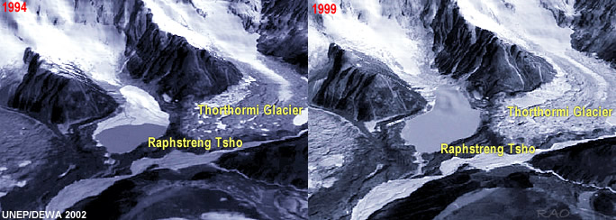
Raphstreng Tsho in Lunana is one of the "dangerous" lakes |
The Raphstreng
Tsho glacial lakein the Pho Chhu Riversub-basin measured 1.6
km long, 0.96 km wide and was 80 metres deep in 1986.
The latest figures (1995)
show the lake has swollen to be 1.94 km long, 1.13 km wide and has a depth
of 107 metres. Its neighboring glacier could generate a GLOF up to two-and-a-half-times
that which caused major devastation in October 1994.
The 43 other glacial lakes, pin pointed in the survey and deemed to be
in a dangerous state, show similar patterns.
 |
| Later,
in 1999, a joint study by Austrian and Bhutanese experts concluded that
the risk of an immediate outburst from the lake was "low" compared with
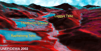
theThorthormi (Thortomi) Tsho. Lying to the east of the Raphstreng
Tsho, theThorthormi (Thortomi) Tsho and its off-shoots at the moment
is considered "very dangerous" by experts after its southern flank was
eroded by the 1994 flood and recommends close monitoring all summer till November every year |
|
Outbursts from the main lake's dam would have similar impact downstream
as the Luggye Tsho flood. To
contain the lake, the department of geology and mines plans to open an
outlet from one of its dam's side."This will be done to channel excess
amount of water when glaciers melt," said the director of the department,
Dorji Wangda.
Other
than that the department has carried out "hazard zonation map" where to-be
affected areas along the Lunana valley have been identified and
settlements cautioned from starting any constructions. Re-settlement of
villages affected by the 1994 flood was also recommended but officials say farmers were reluctant to
move because of sentimental attachments. As a result pictorial manuals
are distributed to help villagers evacuate in case of an impending flood.
Satellite Phones were installed and a wireless station set up along with
two watchmen to monitor the lakes. Moreover work at the site, which is
above 4,000 meters above sea level, is aggravated by the harsh climate.
Dorji Wangda said that the rough terrain to the site, which takes more
than 11 days to walk, is also proving difficult, "especially when you have
heavy equipment to carry."
|
 |
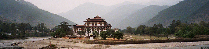
| In 994 the partial outburst from the Luggye Tsho caused the Pho Chhu flood which claimed 23 lives in Punakha valley and damaged a part
of the Punakha dzong. The flood relief measure cost the government
Nu 43 million. In Lunana 12 houses were damaged and 964.74 acres of pasture
land wiped out. Yaks, grain, bridges, water mills, chortens and a temple
were part of the toll. |
|
Two
major floods in the past, both from the Pho Chhu, are also remembered
- one in the summer of 1950,
lasting about 24 hours, and another in 1960 that lasted for five days. They are known to have caused by glacial lake
outbursts. Meanwhile, the chances of a near-future glacial outburst from Lunana seem to pivot on the rising global climate and the toil of geologists.
|
Related
Information |
 |
 |
|
Punakha
Dzong: Confluence of Mo Chhu and Pho Chhu |
|
