|
Nepal Himalayas |
|
Nepal Information |
|
|
 |
|
Brief
description of mountain peaks |
 |
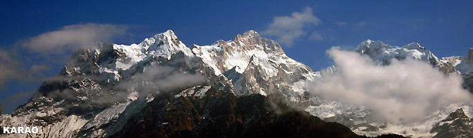
Along
with its many other facets, Nepal is well known for its beautiful high mountain
peaks. Many tourists visit Nepal every year attracted by the scenic
beauty and the challenge of scaling these mountains. A brief description
of these mountain peaks is presented in the following paragraphs.
| Mt.
Everest |
|
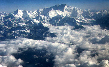 |
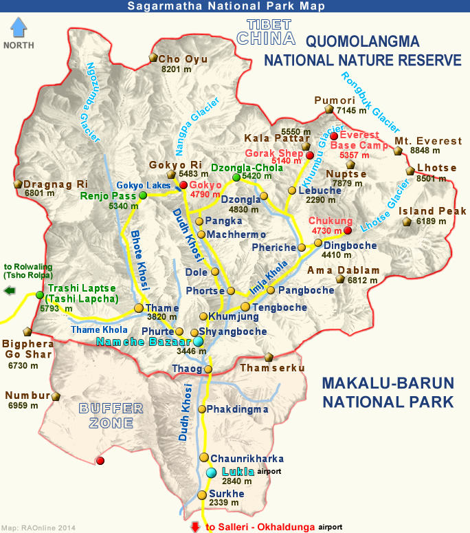
| Mt.
Everest, lying in the Mahalangur range and known as Sagarmatha in Nepal
and Chomolongma in Tibet, is the highest mountain peak in the world.
Mt. Everest is located in the Solukhumbu District of Sagarmatha Zone at 27° 59' 17" N latitude and 86° 55' 31" E longitude. Sir George
Everest, the British Surveyor General of India, discovered it in 1852.
Everest was then referred to as Peak XV. It was officially named Mt. Everest
in 1865 and a Nepali name 'Sagarmatha' was given in 1956. |
|
On 5th May 1999,
its elevation was determined to be 8,850 meters by National Geographic
Society, which was determined using Global Positioning System (GPS) satellite.
The new elevation of Mt. Everest has however not been confirmed by Government of Nepal.
The
best climbing months are April and May and most expeditions set out for
the summit from Namche Bazaar in Solukhumbu.
| Kangchenjunga |
|
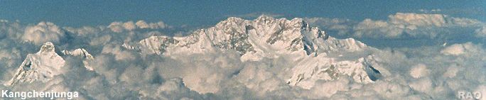
Kangchenjunga,
the third highest mountain in the world (8,586 meters) is located
at 27° 42' 09'' N latitude and 88° 09' 01" E longitude. From 1838
until 1849, it was believed to be the highest mountain in the world. Kangchenjunga
is located on the Indo- Nepal border as part of the Himalayan mountain
range. The mountain was first climbed by a British Expedition Team of George
Band and Joe Brown in 1955.
The
best climbing months are April, September and October. The most feasible
way to approach it is from Basantapur.
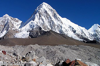
| Lhotse |
|
Lhotse
is the fourth highest mountain in the world. Located at 27° 57' 45"
N latitude and 86° 56' 03" E longitude, the peak has a height of 8,516
meters. Its long east-west crest is located immediately south of Mt.
Everest and the summits of the two mountains are connected by the South
Col, a vertical ridge that never drops below 8,000 meters.
Lhotse is sometimes
mistakenly identified as the south peak of the Everest massif. No serious
attention was turned to climb Lhotse until after Everest had finally been
ascended. Lhotse was first climbed in 1956 as an alternative route to the
summit of Everest by a Swiss team of Ernst Reiss and Fritz Luchsinger.
In addition to the main summit, there are two subsidiary peaks, Lhotse
Shar, which is immediately east of the main summit, and Nuptse,
a high peak on the mountain's west ridge. It is also known as Khumbu Lhotse,
Lotzu or Lo-tzu Feng.
The
best climbing months are April, May, late September and October. The convenient
point to start journey to reach Lhotse is Namche Bazaar of Solukhumbu.
 |
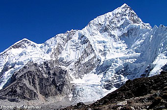 |
| Pumori
(7'165 m) |
Lhotse
(8'501 m) |
| Makalu |
|
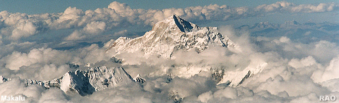
Makalu
is the fifth highest mountain in the world rising 8,463 meters above
sea level. It is an isolated peak, located just 14 miles east of Mt. Everest.
Its impressive structure of a perfect pyramid with four sharp ridges makes
this mountain all the more spectacular. It is also known as Makalufeng.
It is located in 27° 53' 23" N latitude and 87° 56' 35" E longitude.
It was first climbed in 1955 by J. Franco of the French expedition team.
April,
late September and October are the best climbing months.Expeditions to
Makalu starts from Hile of Dhankuta.
| Cho
Oyu |
|
Cho
Oyu, the sixth highest mountain in the world, is located to the west from
Everest and Lhotse in the Khumbu region of Eastern Nepal along the Tibetan
border. It measures 8,201 meters above sea level and located at
28° 05' 37" N latitude and 86° 39' 43" E longitude. It became
a familiar landmark to climbers ascending Everest's north face. Just west
of Cho Oyu is the Nangpa La, a glacier pass, the main trade route between
Khumbu and Tibet.
Cho Oyu's proximity to the Nangpa La has earned it the
distinction among some climbers as being the easiest 8,000 meter peak.
It was first climbed on 19 October 1954 by Austrian climber Herbert Tichy
with Joseph Joechler and Pasang Dava Lama. The mountain is also called Jobo
Uyog.
The
best climbing months are April, May, late September and October. The convenient
place to start a journey to the mountain is from Namche Bazaar of Solukhumbu.
| Dhaulagiri |
|
Dhaulagiri
meaning white mountain is the seventh highest mountain in the world. It
is located at 28° 41' 46" N latitude and 83° 29' 43" E longitude
and is measured at 8,167 meters above sea level. It maintained this
standing for nearly 30 years, until the discovery of Kangchenjunga, which
was then falsely believed to be the world's highest mountain.
Dhaulagiri's
crest stretches for 30 miles, lending structure to an otherwise tangled
topography of twisting ridges, glaciers, and ice falls. In 1960, the Swiss/Austrian
expedition team first reached the summit, despite their airplane having
crashed during the approach and this was the first Himalayan climb supported
by an airplane.
The
best climbing months for the summit are April, May, late September and
October. It can be reached from Pokhara.
 |
|
Dhaulagiri
(left) and the Annapurna Group |
| Manaslu |
|
Manaslu
located at 28° 32' 58" N latitude and 84 ° 33' 43 E longitudes
is the eighth highest mountain in the world. It is 8,163 meters high and is located about forty miles east of Annapurna (8091 m), the tenth
highest mountain. The mountain's long ridges and valley glaciers offer
feasible approaches from all directions, and it culminates in a peak that
towers steeply above its surrounding landscape, and is a dominant feature
when seen from afar.
The name Manaslu is derived from the Sanskrit word
Manasa, which can be roughly translated as 'Mountain of the Spirit'.
It was first climbed by Japanese expedition team members T. Imanishi and
Gyalzen Norbu in 1956.
The
best climbing months are April, May, late September and October. It can
be approached from Pokhara.
| Annapurna |
|
Annapurna
range situated in central Nepal has one of the most dominating Himalayan
panoramas. Located just north of Pokhara Valley, the range consists
of Annapurna I (8,091 m) Annapurna II (7,937 m), Annapurna III (7,555 m),
Annapurna IV (7,525 m) Gangapurna (7,455 m) and Annapurna South (7,219
m).
Annapurna
I is an enormous Himalayan massif and the tenth highest mountain peak in
the world. Located to the east of a great gorge that cuts through the Himalayas
by the Kali Gandaki River, this mountain range has glaciers on its western
and northwestern slopes, which drain into this gorge. Annapurna is a Sanskrit
name that means 'Goddess of the Harvests' or 'The Provider'. Annapurna
I is located at 28° 35' 45" N latitude and 83° 49' 20" longitude.
The
best climbing months are April, May, late September and October. It can
be approached from Pokhara.
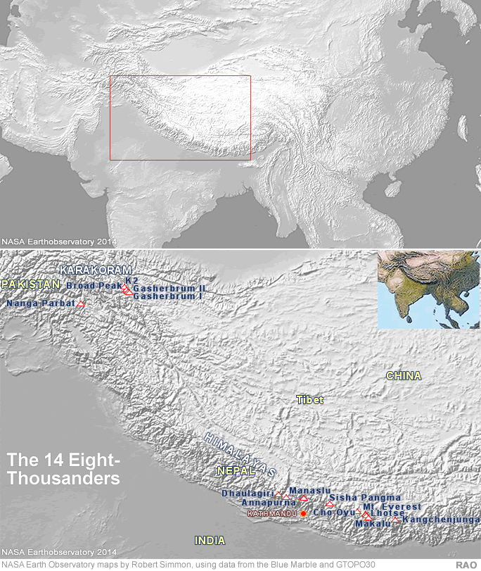
| The 14 Eight-Thousanders |
|
| Information
about the Himalayas in Nepal |
|
| Links |
|
 |
|
External
link |
|