| Natural Hazards in Bhutan |
 |
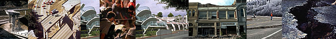
Bhutan Earthquakes |
|
|
Bhutan Earthquakes |
|
|
 |
|
Bhutan's seismic hazard status
|
 |
The Indian institute of technology in Rourkee, India, has done a seismic hazard map of Bhutan showing, for the first time, hazard zones in the event of an earthquake.
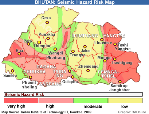 |
| According to the map, Thimphu, Paro, Punakha, Bumthang and Trongsa valleys fall in low and moderate hazard areas, while Haa, Chukha, Trashigang, Mongar, Lhuentse and Trashiyangtse and the southern dzongkhags are in high and very high risk areas.
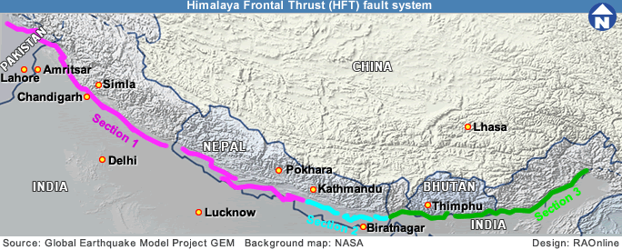
Bhutan so far lacked a seismic map and earlier it was thought that either the whole of Bhutan lay in zone 5 or that western Bhutan was in zone 4 and eastern Bhutan in zone 5. |
|
"The map, however, doesn't give us adequate information on what exactly constitutes a high hazard zone, its Richter scale or geological conditions conducive to earthquakes," said an engineer with the standard and quality control authority, Tshewang Nidup. "It also lacks information on the frequency of the earthquake and whether it would be a short powerful burst or a slower longer one".
Single and double storey structures are more vulnerable during shorter and powerful tremors while multistory buildings are more vulnerable in long and slow ones.
Tshewang Nidup stressed that low hazard areas, as shown in the map, did not mean that the areas are out of danger, because a strong tremor in a nearby high hazard area could also affect them.
While it is agreed that Bhutan lies in one of the most seismically active regions of the world, there is no real consensus on how vulnerable Bhutan is, given the lack of adequate research.
 |
| In 2001, Roger Bilham, an earthquake expert of the university of Colorado, in a study had concluded that an earthquake of 8.1 to 8.3 magnitude would strike the 2,000 km seismically active front of the Himalayas "very soon" to relieve the seismic strain building up along the contact points of the shifting Asian and Indian subcontinental plates, and also because "no" such earthquakes had hit the area in about 500 years. |
|
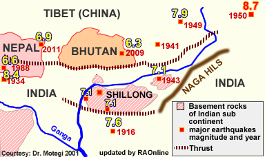
However, in 2005, a JICA expert from Japan, Dr Motegi, working with the geological survey of Bhutan, said that the likelihood of a major earthquake (7-8 on the Richter scale) hitting Bhutan was minimal (see Hazard Risk Study2001)
.
His study showed that the seismic active zone had shifted to about 180 km from the Himalayan foothills to the Shillong plateau, which meant that Bhutan was getting safer with the plate moving away. He argued that Bhutan was safe because, with numerous earthquakes in the past, the build-up stress may have been already released.
In 2001- 2002, a study by the university of Texas and geological survey of Bhutan of five seismic stations in Bhutan recorded 1,600 seismic events in six months, of which 642 events were regional or local events. This seemed to support the notion that Bhutan is less vulnerable to the big one on the size of Richter 8-9 since pressure was being released evenly and not stored up in the seismic plates.
Since 1713 around 19 major earthquakes have hit Bhutan with the epicentres in Bhutan's neighbourhood. The biggest were in 1897, 1905, 1934 and 1950 measuring 8 on the Richter scale. In the opinion of a United Nations study, the worst-case scenario in Bhutan is likely to be a severe earthquake in an urban setting in mid winter as the damage and casualties from the earthquake would be amplified by the prevailing climatic conditions of freezing temperatures.
Meanwhile, a study by SQCA found that around 60 percent of the older buildings in Thimphu were not earthquake resistant. Earthquake resistant building codes were followed in Bhutan only after 1998.
According to SQCA, people should follow the Bhutan building codes 2003 and ensure that the foundation is strong, weight is equal on all floors, thicker walls and pillars, strong lower floors and ensure that beam rods are not joined in the middle or at corners.
 |
A total of 30 earthquakes have been recorded in Bhutan between the years 1937 to 1998. Records with the department of geology and mines indicate that a 1941 earthquake, on January 21, was the most powerful, measuring 6.75 on the Richter scale.
|
| This
article was contributed by KUENSEL, Bhutan's National Newspaper, 2009 |
|
|
Information on Bhutan
|

|
|