| 26. Dezember 2004: Tsunami
im Indischen Ozean |
 |
Erdbeben - Tsunami Informationen |
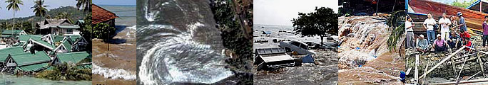
| Leben
an der Küste: Bilder
|
|
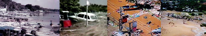
Küsten Bilder |
|
|
Küsten Bilder |
|
| Wo? |
Was? |
 |
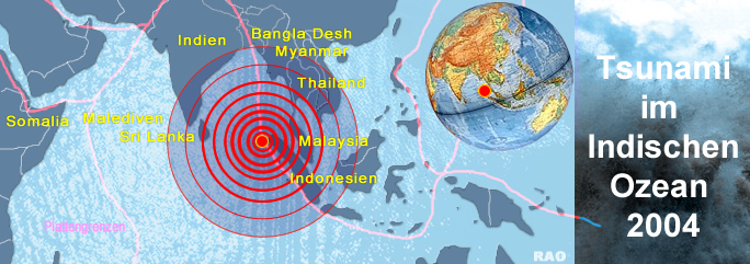
| Das
stärkste Erdbeben seit Jahrzehnten hat in Südasien mindestens
150'000 Todesopfer gefordert. Der Erdstoss hatte eine Stärke von 9,0
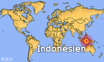
auf der Richterskala. Da das Erdbebenzentrum über 100 km vor der Westküste
Sumatras lag, wurden die meisten Menschen von einer Tsunami (einer
Meeresflutwelle) in den Tod gerissen. |
|
Das
französische Erdbebenüberwachungsnetz registrierte den Erdstoss,
welche die Fluswelle auslöste am 26. Dezember 2004 um 00.58.23 UTC.
Die Flutwelle hat sich über den ganzen Golf von Bengalen bis nach Indien und Sri Lanka ausgebreitet. Das verheerende Seebeben im Indischen
Ozean hinterliess auch an der weit entfernten Küste Afrikas und auf
der Inselgruppe der Seychellen Verwüstungen. Die riesige Flutwelle
liess den Wasserspiegel an vielen Küsten am Rande des Indischen Ozeans
bis 10 Meter ansteigen und überschwemmte Strände und Küstenregionen.
Auch Malaysia ist die Westküste von einer Flutwelle heimgesucht worden. Verheerende
Verwüstungen werden aus der Indonesischen Proviz Aceh am Nordende
der Insel Sumatra (Indonesien) gemeldet.
Die
südöstlich des Epizentrums liegenden Inseln vor der Westküste
Sumatras wurden von der Tsunami besonders hart getroffen. Hier muss mit
einer sehr grossen Anzahl Flutopfern gerechnet werden. In Thailand sind gemäss ersten Schätzungen rund ein Drittel der Opfer Touristen.
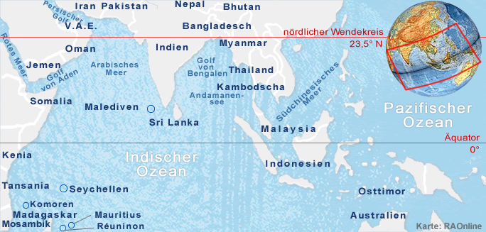
Von
der Flutwelle und Überschwemmungen betroffen waren zudem Bangladesh,
die Malediven, Myanmar (Burma), Somalia, Kenia, und Tansania.
Der
Erdstoss ist der fünfstärkste seit 1900 und das stärkste
seit 1964, als ein verheerendes Erdbeben die Region des Prince William
Sounds in Alaska (Stärke: 9.2) heimgesucht hat. Bereits am 23. Dezember
2004 wurde südöstlich von Australien ein Seebeben der Stärke
8,1 aufgezeichnet. Dieses Beben löste keine Tsunami aus.
USGS
Aufzeichnung:
A
great earthquake occurred at 00:58:50 (UTC) on Sunday, December 26, 2004.
The magnitude
8.9 event has been located OFF THE WEST COAST OF NORTHERN SUMATRA.
Data:
Magnitude
8.9
Date-Time Sunday, December 26, 2004 at 00:58:50 (UTC)
=
Coordinated Universal Time
Sunday,
December 26, 2004 at 6:58:50 AM
=
local time at epicenter
Location 3.298°N, 95.779°E
Depth 10 km (6.2 miles) set by location program
Region OFF THE WEST COAST OF NORTHERN SUMATRA
Distances
250
km (155 miles) SSE of Banda Aceh, Sumatra, Indonesia
320
km (200 miles) W of Medan, Sumatra, Indonesia
1260
km (780 miles) SSW of BANGKOK, Thailand
1605
km (1000 miles) NW of JAKARTA, Java, Indonesia
Location Uncertainty horizontal +/- 9.2 km (5.7 miles) |
depth
fixed by location program
Parameters
Nst=157, Nph=157, Dmin=>999 km, Rmss=1.35 sec, Gp= 29°,
M-type=moment
magnitude (Mw), Version=9
Source USGS NEIC (WDCS-D)
Event
ID usslav
Felt
Reports At least 9 people killed, buildings collapsed and telephone
service disrupted at Banda Aceh. Many people killed by tsunamis in Sri
Lanka and Thailand. Tsunamis also observed on the coasts of Maldives, Cocos
Island and Sumatra. Felt widely in northern Sumatra. Also felt in Bangladesch,
India, Malaysia, Myanmar, Singapore and Thailand. This is the fifth largest
earthquake in the world since 1900 and is the largest since the 1964 Prince
William Sound, Alaska earthquake. |
|
 |
|
 |
 |
|
 |
|