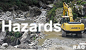
| Natural Hazards in Bhutan |
 |
Bhutan Earthquakes |
|
Sikkim Quake 2011 |
|
|
Bhutan Earthquakes |
|
|
 |
|
A 6.9-earthquake struck Northeastern Nepal and Sikkim (India)
|
 |
September
20, 2011
| This report is produced by OCHA in collaboration with humanitarian partners. It was issued by the Regional Office for Asia Pacific. It covers the period from18 to 20 September. |
The situation on 20 September 2011
As bad weather and heavy fog lifts across a remote and mountainous Himalayan region, the extent of damage from a 6.9 magnitude earthquake is becoming clearer but rescue workers are still struggling to gain access to the most affected areas.
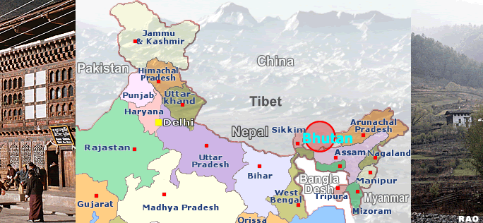
At approximately 1840 local time (1240 GMT) on 18 September, a strong earthquake struck the northeastern Indian State of Sikkim which borders Nepal, Bhutan and China. According to the U.S. Geological Survey the epicentre was 60 kilometres (40 miles) northwest of the Sikkim State capital, Gangtok, at a shallow depth of 20 kilometres. Powerful tremors were felt across a wide area that includes Nepal, China, Bhutan and Bangladesh. Tremors were felt as far away as the Indian capital New Delhi - 1,000 kilometres from the epicentre. Media are describing the earthquake as the biggest in 60 years for the northeast of India.
The earthquake and aftershocks set off landslides, which along with heavy monsoonal rains blocked roads and hampered rescue efforts on day one of the response. The mountainous State of Sikkim is the worst affected with its main road cut off by dozens of mudslides. Heavy fog and poor visibility grounded helicopters and Indian relief and rescue teams trying to access the area. Road crews were able to clear the highway late afternoon on the 19 September. The Government of India has deployed more than 6,000 army personnel to the area for relief operations and to try and restore overland links with Gangtok and further north towards the epicentre. It is hoped that rescue teams will reach Mangan, the earthquake's epicenter, and surrounding areas of north and west Sikkim later today, where major damage has been reported.
Latest media reports indicate that 74 people have died as a result of the earthquake in three different countries. This includes 58 people in Sikkim State, West Bengal and Bihar in India. In China, seven people are dead and 22 injured in southern Tibet. The tremors were felt throughout Shigatse Prefecture in Lhasa Valley. Another six deaths have been reported in Nepal. Hundreds are reported as injured. The number is expected to increase as rescue workers reach some of the more inaccessible mountainous areas in Sikkim State.
In Nepal, hundreds of homes were damaged in eastern part of the country, where rescue workers are facing the same difficulties as their Indian counterparts with rains and mudslides blocking the only highway to the
area. In Bhutan, there have been reports of damaged buildings and infrastructure and some people have been injured. In Bangladesh, tremors were felt in the north western part of Bangladesh including Dhaka but no casualties have been reported.
The Governments in India, Nepal, China, and Bhutan are all managing the response and no requests for additional assistance are anticipated.
|
Countries Affected
India
In the affected area of Sikkim State, at least 41 people have died and hundreds are injured in Gangtok and its surroundings as a result of landslides, mudslides, collapsed buildings and falling debris. The maximum casualties have been in Rangpo, Dikchu, Singtam and Chungthang in north Sikkim. Ten people have died in Bengal and seven in Bihar.
As rescue workers gain access to Gangtok, the closest city to the epicenter with a population of 622,000, the extent of damage is beginning to be assessed. More than 1,000 buildings are reportedly destroyed in Gangtok. The media is reporting that more than 100 people have been injured by mudslides, falling debris and collapsed buildings in Gangtok. Last night thousands of people spent the night in the streets after repeated aftershocks sparked further panic. Roads and bridges between Meeli and Namchi in south Sikkim and Rawangla in west Sikkim have also been severely damaged.
The media says that power, water and telecommunication lines continue to be affected. Efforts are underwayto restore power and telecommunications at the local level. Power was restored in Gangtok and some other areas on Monday afternoon. Schools will be shut for three days and offices have been asked to function only if the buildings have been declared safe. The media reported telephone landlines to Sikkim were knocked out and mobile networks were overburdened, making communications with the affected area difficult.
The Government dispatched 400 National Disaster Response Force (NDRF) teams on the 18 September but they were stuck in northern West Bengal until the weather cleared late on the 19 September. Fortunately, the the Indian Army and Indo-Tibet Border Police personnel stationed in Sikkim have been able to carry out search and rescue efforts. India Air Force (IAF) planes carrying rescue teams and relief supplies have also been dispatched to Sikkim. The IAF dispatched two C-130J Hercules aircraft with 203 NDRF personnel, sniffer dogs, rescue teams, medical personnel and nine tones of relief materials including tents, medicines and food stocks from Hindon to Bagdogra within hours of the earthquake. The military is also assisting with aerial missions to assess the damage. In Darjeeling, also badly hit the earthquake, 15 army units have been deployed in Kalimpong, Algarah, Rishi, Rorathang and Padamchea while four more are in Darjeeling town.
Nepal
The earthquake was felt throughout 22 districts of eastern and central Nepal, including in the capital of Kathmandu, 270 kilometres west of the epicentre. According to the National Emergency Operation Centre six people have died. In addition, 24 people are severely injured and another 77 people have minor injuries. More than 300 houses are damaged. The main affected districts include, Sankhuwasabha, Taplejung, Ilam, Dhankuta, Pachthar, Sunsari, Bhojpur in the Eastern Region, Bhaktapur and Kathmandu in the central region and Syangja and Lamjung in the western region.
The Government of Nepal is managing the response and no request for external assistance is anticipated. The Ministry of Home Affairs (MoHA) is working closely with the countries three security forces in the National Emergency Operations Centre. A cabinet meeting held fifteen minutes after the earthquake instructed all district authorities to carry out Search and Rescue operation without delay. Security personnel were mobilized for search and rescue activities in Kathmandu, Sankhuwasabha, Dhankuta and Sunsari districts.
The Nepal Red Cross Society established a three member task team to communicate and coordinate the response with the affected. The Education Cluster has indicated the loss of several schools across nine districts in the eastern region.
The OCHA Humanitarian Support Unit in Nepal is closely working with MoHA, humanitarian clusters and the UN Field Coordination Offices. Emergency meetings have been held in Biratnagar and Taplejung with partners to exchange information and mobilize relief distribution.
Save the Children have 50 shelter kits ready to distribute in Taplejung and Bhojpur districts and 500 kits on standby. They are planning to establish temporary schools in the two districts and have already provided 100 tarpaulins.
Bhutan
In Bhutan, buildings in the capital Thimphu also moved with the tremors, roads were blocked by landslides. The Bhutan Department for Disaster Management (DDM) under the Ministry of Home and Cultural Affairs issued a preliminary report on damages. Dzongkhag (provincial) officials report minor damages to houses and infrastructure and a number of injuries. The extent of damages will be known after a field assessment by Dzongkhag officials.
 |
| Source: OCHA, September 2011 |
|
|
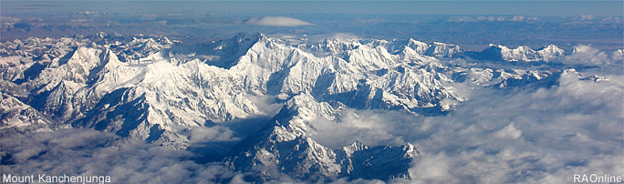
Mount Kanchenjunga (Taplejung, Nepal), border area to Sikkim
|
| Links |
|
 |
|
External
link |
top
| Information on Bhutan |
|
|