|
Bhutan's
glaciers and glacial lakes |
 |
Bhutan Glaciers - Glacial Lakes |
|
|
Bhutan Glaciers - Glacial Lakes |
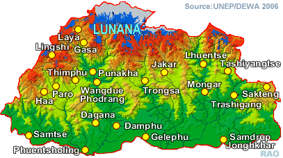
| Glacial
lakes in Bhutan Map |
|
|
 |
 |
|
Although
there is no immediate danger, the presence of a peculiar micro-organism |
| on
the surfaces of glaciers could accelerate glacial melting and eventually
lead to a glacial outburst, according to a preliminary survey report . |
|
|
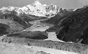
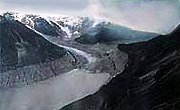
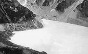
Out
of more than 677 glaciers and 2674 glacial lakes lakes in Bhutan, about
24 are identified as potentially dangerous. Tshoju is identified as the
longest glacier measuring about 13 kilometeres in length.
 |
Tarina Tsho |
|
 |
 |
 |
 |
|
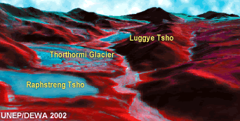
Luggi
(Luggye) Lake |
Luggi
(Luggye) Glacier |
Raphstreng
Tsho |
top
| Lakes
in Lunana with high GLOF (glacial lake outburst flood) risks |
 |
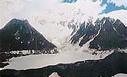
Of
the four major lakes in Lunana experts have identified the Thorthormi
(Thortomi) as potentially the most dangerous because of some weak points
along its natural dam. They have also identified the safe and unsafe areas
in the region, in case of a flood.
 |
| The developingThorthormi(Thortomi) lake (in the foreground) is 50-60
metres above the Raphstreng lake (Photo by Nozumo Naito, Nagoya University) An
Austria-Bhutan geological team which finalised its study this month pointed
out that theThorthormi(Thortomi) glacier was melting and the lake,
situated more than 4,500 metres above sea level, was growing. |
|
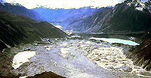
If the lake
did burst, perhaps in 10 years if preventive measures were not taken, it
could also create a "cascading" effect and also pressure the Raphstreng lake, about 50 to 60 metres below it, into bursting, according to the
department of geology and mines.
The
result could be a flood with a downstream impact volume of 17-22 million
cubic metres.Thorthormi(Thortomi) and Raphstreng, both sources
of the Phochhu, are divided by a moraine dam which has risky segments.
The Throthormi lake's southern flank was eroded by the 1994 flood. "Furthermore, a physical risk assessment of theThorthormi(Thortomi)
supra-glacial lake is difficult because of the extremely dangerous crevices
on the surface," said Dorji Wangda, the director of the department of geology
and mines (DGM). "We cannot even carry our geo-physical instruments there."
A
Japan-Bhutan survey team of glacier-microbiologists, glacio-ecologists
and geologists recently reported that the potential of an outburst of the Throthormi
lake was higher since the 1994 Luggye
lake flood had made the left lateral moraine
unstable.
|
| As
preventive measures the DGM, with its international partners, would create
outlets so that the water will flow naturally. |
|
 |
|
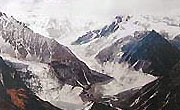
Tarina |
|
Lunana
glacial lake |
The Austria-Bhtuan team
had demarcated safe and unsafe zones for settlement in Lunana and
the need for infrastructure between Tami Damchu and Khuruthang
in Punakha valley.
If
the lake burst the people along Lunana valley might have only 20
minutes to move out. Thenza, Denji, Tshojo, Lhedi, Shangsa and others
villages were most risk prone areas. The team has identified the places
where people could go for safety in case of a flood. It has also identified
emergency helipads for rescue operations. Some of the other risk prone
areas are the settlements along the river bank which are on the lower terraces.
"The schools and resort in Khuruthang could be flooded and washed away,"
the Austrian professor Hausler said.
| "The
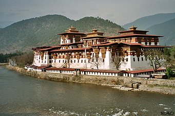
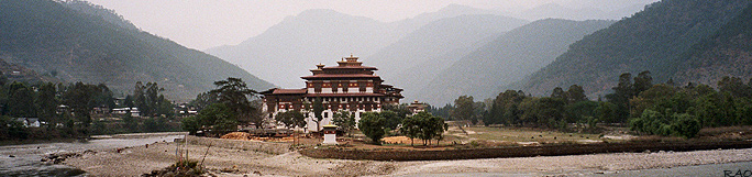
Punakha dzong will be safe although the dzong premises could be flooded.
Parts of Wangdue-Punakha road lying on low terraces will also be
completely washed away, paralysing the rescue operations." The study team
has recommended that these parts of the road be relocated to higher terraces.
The demarcation represented a worst flood scenario. The department, with
assistance from the flood warning unit and funds from the government of
India, has installed two technical early warning systems in Lunana to warn the people downstream in time on the impending danger. |
|
 |
The 1994 flood took seven hours for the flood to reach Punakha, a distance
of 90 kilometres from the Luggye lake. Scientists predict that if
there is a flood this time it will take less time since the earlier flood
had made the track for a smoother flood clearing the debris away.

 |
|
Punakha
Dzong: Confluence of Mo Chhu and Pho Chhu |
|