|
Dhankuta |
Dhankuta is
a charming hill town of cobbled streets and whitewashed houses populated
by Rais, Limbus and Newars. Situated at an altitude of 1,220 m north of
Biratnagar in east Nepal, it is about 50 km from Dharan, formerly a recruitment
centre for British Gurkha soldiers. The villages north of Dhankuta are
the trailheads to the Makalu and Kangchenjunga regions.
|
Dolakha |
Dolakha is
an old settlement known for its shrine of Dolakha Bhimsen, the patron
deity of businessmen. It is 4 km from Charikot (133 km) on the Lamosangu-
Jiri Highway that branches off to the east from the Arniko Highway at Lamosangu.
Dolakha is a chance to visit an historic place and enjoy fantastic near-
range views of Mt. Gauri Shanker.
<
|
Godavari
- Royal Botanical Garden |
 |
| Located
at the Foot Hills of Phulchowki ( 2,758 m high), one of the highest hills
surrounding Kathmandu valley. The road from Patan city runs to Godavari
to the southeast, passing through the small old towns of Harisiddhi, Thaiba
and Badegaun. The only botanical garden in Nepal, it is open daily including
Saturdays and Government holidays. In this place, a holy pond known as
"Kunda" is located. |
|
A
fair is held in every gap of 12 years where most of pilgrims come to take
bath. It is believed that taking bath in the cold water at this holy pond
makes one to free from all the skin diseases. The garden is landscaped
over 72 hectares of land. Over 500 species of plants can be found in the
various gardens. The peak flowering season falls in spring and in autumn.
The coming of spring is indicated by the bloom of Rhododendron Arboretum,
the national flower of Nepal, and the dramatic appearance of a number of
colourful flowers in the garden beds and the surrounding forests. The gardens
are also the dwelling place for butterflies, Godavari area being a reservoir
for hundreds of species. Maps and plant listings are available at the entrance.
A small admission fee is charged.
Phulchowki
is a good spot for hiking. A Buddist shrine is situated on the top of the
hill which can be reached through a jeepable road. The VHF tower of Nepal
Television is located at the top of the hill.
Godavari
Springs
Very
close to the Botanical Garden (200 metres away from the main gate) is what
is called in Nepali, 'the Godavari Kunda', a fresh water spring forever
spouting forth cool, crystal clear water. A pilgrimage place revered by
both Hindus and Buddhists, the water is channeled through five carved stone
spouts Panchadhara in Nepali) where pilgrims bathe, drink and worship.
There are various temples and a retreat monastery in the surrounding vicinity.
Hindu legend has it that a certain realized saint, Bahadur Puri Swami,
in ancient times used to walk to the River Godavari in India daily to take
a purification bath. The Goddess being pleased with his devotion, manifested
herself at his doorstep so that he did not have to walk the distance everyday.
The Buddhists believe that the Great Indian mystic, Padmasambhava, who
initially introduced Vajrayana Buddhism in Tibet, while passing through
Nepal struck the root and created the spring in order to symbolize the
ultimate truth - always clear, always fulfilling the thirst of people for
supreme knowledge.
 |
|
Gorkha |
Gorkha
is situated 131 km west of Kathmandu at an altitude of 1,135 m at the end
of a mountain road that branches north from the Kathmandu- Pokhara highway
at Abu Khaireni. It is the ancestral home of the shah dynasty and home
of the original Gorkha soldiers. Gorkha's centrepiece is the magnificent
Gorkha Durbar that is a fort, a palace and a temple with excellent views
of the surrounding valleys and the Manaslu range.
<
|
Janakpur |
Janakpur is
the birthplace of Sita, heroin of the great Hindu epic. Ramayana is situated
in the Terai plains. Thousands of pilgrims flock here throughout the year
to pay homage at the Janaki Mandir, Ram Sita Bibah Mandap and Hanuman temple.
Janakpur is the centre of Maithili culture and the magnificent Janaki Mandir
is one of Nepal's architectural showpieces. It is 375 km southeast of Kathmandu.
<
|
Kodari |
Kodari lies
on the Nepal China border 114 km to the northeast of Kathmandu. The village
(altitude 1,640 m) has an exotic history as the starting point of the ancient
trans Himalayan caravan route, the Nepalese equivalent of the Silk Road.
The Arniko Highway connecting Kathmandu and kodari takes you through magnificent
river gorges and mountain scenery. The famous hot water springs Known as
Tatopani are situated 3 km before Kodari.
<
|
Kathmandu |
"Heritage
Road"
The
extension of the Sampada Marga (Heritage Road) for reaching to the historical
and archaeological sites of Kathmandu Metropolis has reached its final
stage. The route incorporates Kamalakshi, Asan, Indrachowk, Hanuman Dhoka
and Paropakar Secondary School, Thahity, Bangemudha, Bhedasingh, Kilagal,
Hanumandhoka, Adko Narayan, Chikanmugal, Hyumata and Teku. Similarly, the
road starting from Chhetrapati, Tengal, Naradevi, Pyafal, Makhan, Hanuman
Dhoka, Jhochhen, Lagan and Pachali is also named Heritage Road. The metropolis
is to publicise and hold interactions and distribute brochures on this
which is aimed at publicising the major historical heritages to the world.
<
|
Mustang |
The
Upper Mustang was opened as a restricted area since then only 1000 foreigners
are permitted annually for tourists in 1990.
The
Mustang region is dry, desolate and windy, and is a paradise like no other
on earth. Strong winds blowing up between the Annapurna and Dhaulagiri
mountains have created a dry desert landscape- dusty and bare in all its
beauty. Because of dry climate found over here agriculture is impossible
without irrigation and agro-productive land is also very nominal. Polyandry,
marriage of one woman with two or more brothers, is still in practice to
avoid the splitting of the family's farmland. But like all traditional
ways, these are changing too.
The
face of Lo Manthang is gradually changing. The dirt road extended from
Tibet passing through Nechung to the medieval settlement of Lo Manthang
was completed some months ago. It has started to show its impact not only
on the local economy but also on the local environment and community as
a whole.
<
|
Namche
Bazaar |
Namche Bazaar lies
on a lap of Khumbu Himal range. Namche Bazaar is about 241 km from Kathmandu.
It can be reached be the Arniko Highway and the road to Charikot and Jiri.
From Jiri there will some days of trekking to Namche Bazaar. But it is worth
to do that trek across the Solu-Khumbu area. This place is the home of
the legendary Sherpas. One can fly from Kathmandu to Lukla and Thyangboche
in the Everest region.
<
|
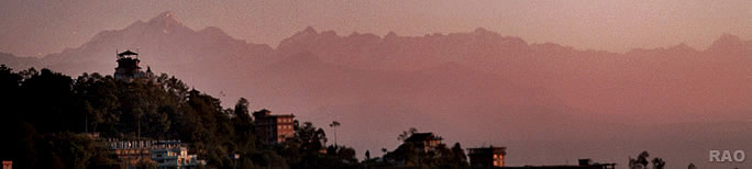
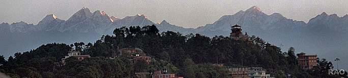
Nagarkot |
Nagarkot
is a popular tourist destination of Nepal. It is situated 32 kilometers
east of Kathmandu at an altitude of 2,170 m. Nagarkot isn't much of a village,
but there are more than a dozen lodges.
The
panoramic view of the major peaks including Mt. Everest can be seen from
here. The view point tower offers the best vantage point from where you
can get a 360-degree panoramic view of the Himalaya. Nagarkot boasts a
200-mile panorama of the Himalayas that extends from Dhaulagiri in the
west, to Ghaurishankar Himal range and to beyond Mount Everest in the east.
This place is also famous for viewing sunrise and sunset.
<
|