|
|
|
 |
 |
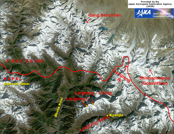 |
Figure
depicts the Shishapangma (also known as Gosainthan) and Langtang Mountains
in the Himalayas observed by AVNIR. The white sections are mountainous
areas covered with snow. The steep mountains seem to cast their own shadows
on the tops and the ridges, upper left. This is because the observation
time was before noon local time as the sun shone from the lower right.
Nepal is in the lower portion of the figure, and Tibet, China, is in the
upper portion, with the complicated border lying in an east-west direction.
Shishapangma is on the right of the figure, 8,012 m above sea level on
the Tibetan side. You can see other seven-thousand-meter peaks, including
Langtang Ri (7,239 m above sea level), Gang Benchhen (7,211 m above sea
level), and Langtang Lirung (7,245 m above e sea level). Some glaciers
can be seen in the center of the figure near the bottom of Langtang Valley
on the Nepal side. Many glaciers line up in the northwestern area around
Shishapangma on the Tibetan side. Some glaciers on the Tibetan side have
glacial lakes downstream that look copper green or pale emerald green.
The
growth and melting of glaciers are considered indices of global warming,
and some reports say that glaciers are easily affected by global warming
in places at relatively low latitudes and high altitudes, as in the Himalayas
and Tibet. As glaciers retreat and contract, glacial lakes collapse, flooding
downstream areas and causing a rise in sea level. For this reason, we have
to continue careful observation.
Valley
bottoms less than 1,500 m above sea level (lower left) appear veiled. This
could indicate air pollution in the Katmandu basin. The mountainous area
and Tibetan Plateau (higher than 3,000 m above sea level) look clear because
the thin atmosphere has little influence on visibility.
Source:
Website of the Japan Aerospace Exploration Agency (JAXA)
| more
information and pictures |
 |
| Links |
|
 |
 |
External
link |
 |
| Japan
Aerospace Exploration Agency JAXA |
|
 |
|