Trekkings
previous page
end
Charikot and Dolakha - Trekkings
Charikot - Bigu - Kalinchowk
Charikot Photo Galleries
Map
Charikot Trekking Route
Distance: We have opted for approximate and 'comfortable' walking times rather than distances in miles, kilometres or 'kosh'.
Charikot - Bigu - Kalinchowk
Trekking
Day 1:
Kathmandu-Charikot (133 km, by bus or car)
Day 2:
Charikot - Dolakha - Nagdah - Pikhuti (Pikhuti) - Singati (5 - 6 hours)

The climb down to Nagdah is an extremely steep one: allow for much more time on your way back. After Nagdah, the trail leisurely follows the Tama Koshi through pine forests. Stay overnight at Singati (1 hour).

larger video
Nagdah Village Tama Koshi Valley
Day 3:
Singati - Chagu - Bigu (7 hours)
The trail follows the Sangewati Khola on the left side for about three hours until you reach a place called Sunung Khoh. A teashop serves 'dhal-bhat' on order here. Then comes a steep climb up to Chagu and again down to the river at Sangbe where there is a newly built suspension bridge. A less than average trekker should stay overnight either at Chagu or Sangba and attack the steep trek up to Bigu (2 hours) on the following morning.

Food and shelter are available at Sangba or infamnaly, with some of the richer people at Chagu

Day 4 and 5:
Bigu - Tinsang La - Kalinchowk - Charikot (10 hours)
Bigu - Tinsang La - Barhabise (8 hours)

You 
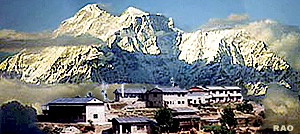
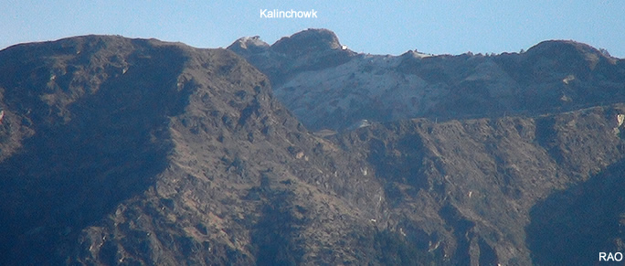
can return to Charikot via Tinsang La (3319 m) and the Kalinchowk range (3,810 m). This can be done with a very early start from the Bigu monastery and if you are a very fast trekker, in one day, but it is more likely to take you a day and a half. You can reach Tinsang La in three hours and, if the shepherds are there, find very "down-to-earth" accomodation with them. On top of Kalinchowk and a little below on the 
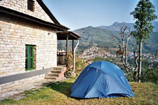
other side are houses where accomodation is avaliable. The second hour is inhabited by a Yogi who accepts guests around his fireplace. In early spring watch out for snow. In the spring you might run into a hail storm on the top of the mountain, a rather unpleasant experience. This route is, however, a most beautiful and exciting one, especially in autumn when birds and wildlife abound.

You will need a guide here as the trails are numerous and ill-defined. Water sources are scarce and little known. Avoid returning by the area around Tarebhir as this is a most tiresome and difficult trail and the area is extremely poor in food crops.

An 
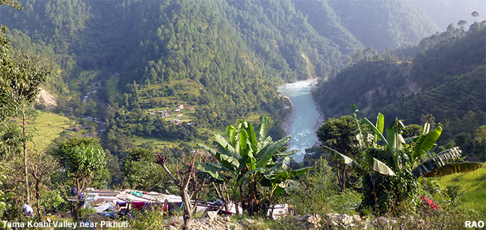
alternative to the Kalinchowk route is to go down from Tinsang La to Barhabise (5 hours) along the old trekking route on the ridge above the Sun Kosi valley. After a long day's walk you are compensated for your labours by all the blessings of electricity; light without smoke, cool drinks and comfortable lodges.

Specific Points to Note

Between Nagdah and Pikhuti you will pass through Malepu. In the autumn, waterfalls literally gush over the cliffs. A teashop under a jackfruit-tree offers a welcome occasion for a stop. One can buy guava along this route.

Often to be seen are porters carrying huge slabs of slate from the mines of Alampu, one of the biggest slate deposits in Nepal. Both the mining and the portering of slate (we have met porters ,with up to 70 kg loads) are occupations which place extreme strains on human beings - another dark side of poverty.

In Singati you can buy some rice and take it along, for your Sherpa hosts will love to share it with you in retum for a comfortable place by the fire.

Map
Tama Koshi Valley
larger video
Hanuman Langurs Tama Koshi Valley
larger video
Crossing the River Tama Koshi Valley
Nepal Videos
Kalinchowk from Charikot
Earthquakes in Nepal
25 April 2015 M 7.8 Earthquake 12 May 2015 M 7.3 Earthquake
in pictures
Charikot Region Images after the earthquake
Singati Region Images after the earthquake
Old Dolakha Images before/after the earthquake
more information
Tinsang La - Rolwaling Trekking Bhutan Flight over the Himalayas
Tinsang La - Kalinchowk Trekking Nepal Himalayas: Air view
Hanumante Trekking Everest Region
Charikot - Dolakha Galleries
top
previous page