|
Erdbeben Karten |
|
Erdbeben Weitere Informationen |
|
| Geomorphologische Karte der Meeresböden |
 |
| First Digital Global Seafloor Geomorphic Features Map Published |
|
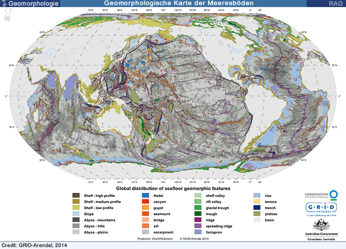
The first digital, global-scale, geomorphic features map (GSFM) of the oceans was recently published by GRID-Arendal, Geoscience Australia and Conservation International.
The map illustrates its applications for scientific research and ocean management.Information to guide global scale management decisions includes the representativeness of features within ocean basins, exclusive economic zones, as well as existing marine protected areas (MPAs), and an inventory of features in the area beyond national jurisdiction (ABNJ).
"The new seafloor features map provides a foundation on which to build an understanding of the living and non-living resources of the ocean and to improve decision making on a range of global issues like food security, resource use and conservation", said Dr. Peter Harris, the project leader and newly appointed Managing Director of GRID-Arendal.
The map is free to download from: https://www.bluehabitats.org
As just one example, analysis of the map shows that features that are ecologically important for fisheries and biodiversity conservation are poorly represented in MPAs: only 4.3% of guyots, 5.0% of ridges and 2.9% of seamounts are within existing MPAs.Submarine canyons, features associated with productive fisheries and whale feeding grounds, are almost entirely within the jurisdiction of countries (91.9% within EEZs) but only 3.4% are protected in MPAs.
Dr. Miles Macmillan-Lawler, mapping expert from GRID-Arendal, noted that "the GSFM includes 131,192 separate polygons in 29 geomorphic feature categories that we have used to assess differences between passive and active continental margins as well as between 8 major ocean regions; the Arctic, Indian, North Atlantic, North Pacific, South Atlantic, South Pacific and the Southern Oceans and the Mediterranean and Black Seas".
The GSFM was published in the science journal Marine Geology (50th Anniversary Special Issue):
Harris, P.T., Macmillan-Lawler, M., Rupp, J., Baker, E.K., 2014. Geomorphology of the oceans. Marine Geology 352, 4-24 https://www.sciencedirect.com/science/article/pii/S0025322714000310
|
| Source: GRID-Arendal, June 2014 |
| Links |
|
 |
|
Externe Links |
nach
oben
| RAOnline: Informationen über Länder |
| Oman - Land am Rande der Kontinentalplatten |
|
|