|
Bhutan Economy |
|
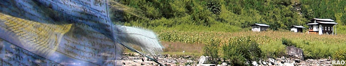
Bhutan Information |
|
|
 |
|
Trashigang:
Radhi's critical state of the environment
|
 |
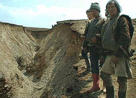
The
Chongdiri ravine
Courtesy
RNRRC Khangma |
Starting
this winter, every farmer in Radhi geog in Trashigang will take
up winter cropping in keeping with a by-law the geog adopted recently.
This new
initiative to cultivate wheat, mustard, and vegetables during winter,
is aimed at gradually reducing grazing area in the geog, ultimately
to get rid of unwanted cattle population. |
|
 |
Rising cattle population and
overgrazing is one of the many reasons for Radhi geog's poor state of
the environment. Since 1981 the geog has experienced numerous landslides and heavy soil erosion almost
every year.
The Chongdiri
landslide, at the peak of the Radhi slope, started as a scratch but
intensified in 1998 and in 2001.
In two decades, the landslide has eaten agricultural land of a 65-acre
area, killed about eight people and about four households had to be
relocated. At the top of the Chongdiri landslide is Sheytimi, an open
area of approximately 3800 acres which has served as grazing land for
Radhi geog and the Brokpas of Merak for generations. The two communities
have been at loggerheads over the rights to graze in the area for years.
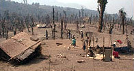 |
The results of indiscriminate exploitation of natural resources in Sheytimi
Courtesy
RNRRC Khangma |
| According
to reports of the RNRRC Khangma about 1000 cattle from Radhi and over
900 cattle from Merak graze at Sheytimi through the year. |
|
The
area is today stripped of all possible fodder trees and all large trees
have been felled. The existing dense bushy vegetation is the only supply
of fuelwood for Radhi.
Experts
say that the management of the Chongdiri watershed, which is part of the Gamrichu
watershed that includes Radhi, Phongmey and five other geogs has reached
such a critical stage that if not taken care of now, it would destroy Radhi
in the future. "It's bad," says research officer Thinley Wangchuk of renewable
natural resource research centre (RNRRC), Khangma. "While geographically
the tectonic movement is more at the particular region, increased population
and livestock over the years have made it worse." Of the 27 landslides
including landslips and gullies in the Radhi-Phongmey region, 22 were in
the Chongdiri watershed and 15 were new occurrences.
top
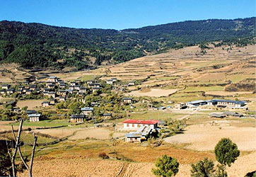
| Ura
Valley, Mongar, dry farming |
| Seven
villages along the Chongdiri watershed area were affected and the
worst degradation was at its upper catchment area where Tongling village
is located. "Cracks have started appearing on the ground surface in all
the villages near Chongdiri," says the district agriculture officer of
Trashigang, Chimi Rinzin. Researchers at Khangma say that indiscriminate
exploitation of the natural resources has contributed to Radhi's degradation. |
|
 |
During the 70s, Radhipas felled trees extensively for timber and fuelwood,
farming activities and for human settlements. Increasing human and
livestock population led to overgrazing and extensive lopping of the few
existing trees for fodder.
Poor
drainage also caused overflow and seepage from paddy fields and irrigation
channels and from the Radhi-Phongmey feeder road. All this plus the higher
tectonic movement in the area where Radhi is perched has disturbed the
hydrological equilibrium triggering the Chongdiri ravine, other landslides
and gullies, says Thinley Wangchuk
Since 1998,
the dzongkhag forestry, a project called Third Forestry Development project (now formerly closed), the RNRRC Khangma and the local community
have been doing their share of saving the other half of the 'rice bowl'
of Trashigang. A 10-kilometre barbed wire fencing is being put near the
slide area under the catchment protection programme and includes fencing
of the upper catchment of the ravine, Sheytimi - the most critical environmentally
degraded area of the dzongkhag.
As
other measures to protect the watershed, about 11 acres of trees have been
planted by the third forestry development project in 1999.
The dzongkhag forestry office also planted trees in 125 acres in 2001
and about 32,040 trees a year. The research centre in Khangma planted
11,235 trees this year. Natural resource management farmer groups are repairing
the Khayshongrong irrigation channel and stabilising critical drainage
lines including that of the feeder road. Other activities include livestock
development programme, supply of seeds and seedlings for pasture development
and fodder conservation.
But
the degradation continues. In August 2003, the Yuidiri stream, that flows
between Radhi and Phongmey washed away the Yuidiri bailey bridge and posed
a risk to about six households located on its north. "It is definitely
a manifestation of critical watershed management," says DAO Chimi Rinzin.The monsoon this year also saw numerous swollen streams triggering landcapes
| Contributed
by KUENSEL, Bhutan's National Newspaper, 2006 |
|
top
| Information on Bhutan |
|
|