|
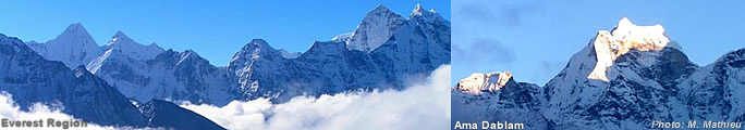
Nepal Himalayas |
|
|
|
|
Virtual conquest of a summit - Mount Everest in 3D
|
 |
DLR researchers recreate the 'Roof of the World' using optical satellite data at a resolution of 50 centimetres - a collaborative venture with DigitalGlobe and 3D RealityMaps
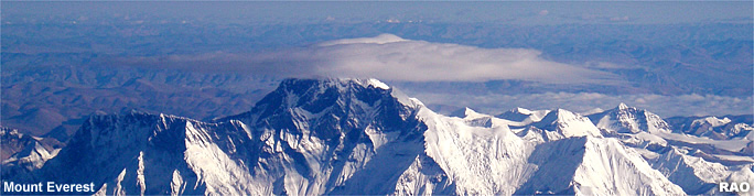 |
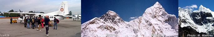
| Mount
Everest (8,848 m) and Lhotse (8,516 m) |
For the first time, researchers from the German Aerospace Center (Deutsches Zentrum für Luft- und Raumfahrt; DLR) have depicted Mount Everest, the 'Roof of the World', in 3D using optical satellite data at a maximum resolution of just half a metre. These 3D images are the outcome of a collaborative venture between the DLR Institute of Robotics and Mechatronics, the German company 3D RealityMaps GmbH and DigitalGlobe, one of the world’s leading providers of commercial, high-resolution Earth observation products. A video allows the viewer to follow the route taken by 15 mountaineers on a current expedition to the summit of the world’s highest mountain.
Data from Earth monitoring satellites evaluated
DigitalGlobe provided the Berlin-based DLR researchers with data from the two optical Earth observation satellites WorldView 1 and WorldView 2. This material was supplemented by imagery from Germany's RapidEye satellite system. The researchers derived a very accurate 3D model of Mount Everest using specialist software developed by the DLR Institute of Robotics and Mechatronics.
"DigitalGlobe made this satellite data available to various international institutions with the goal of generating high-resolution three-dimensional models from it," explains Frank Lehmann, head of the Sensor Concepts and Applications in Optical Information Systems department at the Institute of Robotics and Mechatronics. DLR was one of those institutions.
In total, ten regions of special scientific interest were used in this process. These included Mount Everest; at 8,848 metres, it is the highest summit on Earth. Usingsatellite images taken from different viewing angles, the software developed by DLR then uses these to produce high-resolution 3D surface models and related image information.
Following the route of a real expedition
After deriving the surface model, the data is exported to software produced by RealityMaps.
This enables the data to be depicted in the form of a 3D model andview it from all sides. "This makes it possible, for the first time ever, to make a 'virtual ascent' of Mount Everest in 3D," explains Lehmann. Anyone wishing to experience it first-hand can visit the web page at www.everest3D.de and follow the group of 15 mountaineers on their journey. The expedition started out on 15 April 2011, and the group is expected to reach the summit between 16 and 20 May 2011.At present, the group is above Camp 2.
Zwischen dem 16. und 20. Mai 2011 soll die Gruppe den höchsten aller Gipfel erreichen. Momentan befindet sich die Gruppe oberhalb von Camp 2.
Mars acted as godfather
The software developed by DLR, now being employed on the highest point on Earth, is based on technology that was first tested at entirely different 'heights' and far away from Earth. The role of 'godfather' in this project was played by the planet Mars. To be more precise, this trial involved the High-Resolution Stereo Camera (HRSC) developed by the DLR Institute of Planetary Research as part of ESA's Mars Express mission. This camera system enabled the highest mountain on the Red Planet, Olympus Mons, to be depicted in 3D three years ago.
Documenting climate change
As well as Mount Everest, the DLR experts in optical satellite data have also depicted a forested region of Hawaii, snow-clad mountain chains and major cities such as Mexico City and Berlin. "This proves that, with the right software, high-resolution 3D models of landscapes and cities worldwide can be generated," says Lehmann. For example, these models enable researchers to extrapolate parameters relevant to the environment, and draw conclusions regarding topographical changes.
"This high resolution enables us to calculate volumetric changes in glaciers to determine seasonal variations in snow depths and, from that, to draw conclusions about reserves of drinking water and rates of snow melt," explains Lehmann. The measurement of earthquake zones and surveying are other important fields of application for the new methods being developed at DLR.
The altitude values from the satellite data are calculated for individual 50-centimetre pixels with a height resolution of 50 centimetres. At the present time, this is the highest possible resolution for an elevation model that can be obtained using civilian satellite data. As a benchmark, some of the older aerial photographs you find in Google are based, according to Frank Lehmann, on terrain models with a resolution of 90 metres; in Europe and North America, resolutions of 30 metres are available for certain areas. This low resolution means that buildings or trees do not appear as individual, raised objects.
| Source:
DLR - German Aerospace Center, May 2011 |
|
top
|
Information
on Nepal's Himalayas
|
|
|
Links
|
|
|
 |
|
External
link |
|